Libro Aperto (it would sound like “Open Book” in English) is a mountain in Italy on the Apennines, located on the border between Tuscany and Emilia, characterized by two peaks, Monte Rotondo (1,937 m; 6,355 feet) and Monte Belvedere (1,896 m; 6,220 feet), which look like an open book if observed from afar, as the name suggests.
This is a beautiful hiking trail in Tuscany from Abetone (1,388 m, 4,554 feet), during which you will see fantastic landscapes and enjoy amazing views. I took this hike in August 2020 to escape the crowds on the beaches and it was definitely a great experience. It is not an easy hike, as it is about 12 km (8 miles) long round trip, with an elevation gain of 660 m (2,165 feet). It took me about 4 hours round trip (time spent on top of the mountain not included). Nonetheless, the first part of the hike is accessible to everyone. Remember to bring enough food and water with you, in particular if you take this hike in the summer, as it gets quite hot despite the elevation.
How to get to Abetone
Abetone is a lively mountain tourist destination in Tuscany, in the province of Pistoia. It is popular both in the summer, for its hiking trails, and in the winter, for its ski slopes.
If you are in Tuscany, the easiest way to get to Abetone by car is to take the A11 highway (also known as Firenze-Mare as it connects Firenze to the west coast of Italy) and take the exit to Pistoia. From here, follow directions to Abetone. Otherwise, you can take the road through the mountains from Lucca (Strada Statale 12 dell’Abetone e del Brennero), which will merge with the previous road in the village La Lima. This is a beautiful scenic drive: along the way you will have the opportunity to see some awesome landmarks, such as the “Ponte del Diavolo” (the “Devil’s Bridge”). When you are in Lucca, you just need to follow directions to Abetone.
Once you get to Abetone, there are various parking lots available. Just don’t arrive too late, as they get full quickly, especially during the weekend.
How to get to Libro Aperto from Abetone
After passing the main square of Abetone, coming from Pistoia, turn right onto Via dell’Uccelliera. After a few steps you will find the beginning of the hiking trail on the right, marked by a sign on the street.
Keep walking along this path through the wood and pass the iron barrier. You are now on the CAI trail 00.
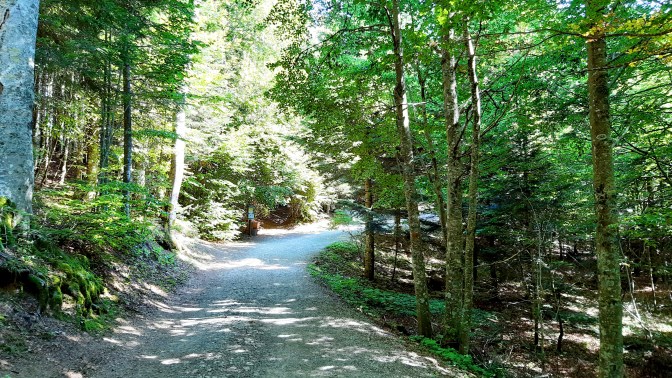
After a couple of kilometres, you will find a large space with a small fountain and some wooden tables. From here three different trails begin: you can either take the one in the middle (CAI trail 00), which will lead you through Monte Maiori, or the one to the left, which is a forest road. I took the latter. However, going forward, the two trails merge at “La Verginetta”.
After a few steps past “La Verginetta”, you will get to a beautiful plateau with a mountain hut named “La Casetta di Lapo” (it would sound like “Lapo’s home” in English). Here, you can have a picnic on the meadow, relax and enjoy the amazing landscape.

At this point you have walked about 3.5 km (2 miles): this can be a good place to stop for those who don’t feel like taking the second part of the hike. In fact, as I mentioned above, from here the trail becomes quite steep until the top of the mountain. You have got two options from here to get to the top of Libro Aperto:
- keep hiking along the CAI trail 00;
- follow the CAI trail 495 on the left.
You can also make a loop trail, as I did: in fact, I followed the CAI trail 495 uphill and the CAI trail 00 downhill on my way back. From this point forward, it is very important to wear hiking shoes (recently I have bought the great Dolomite Diagonal Pro Mid GTX), since the path is rocky and you might slip on gravel or stones.
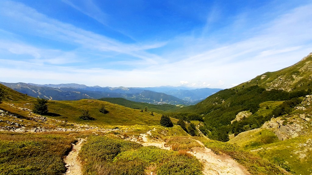
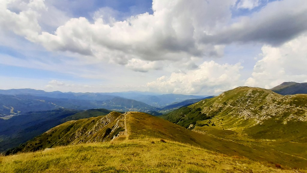
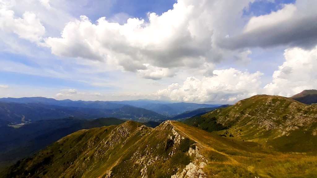
When you get to the top of Libro Aperto, you will be well rewarded for your effort. The landscape is spectacular and the views are wonderful: hiking along the mountain ridge is always thrilling to me! Moreover, this ridge marks the border between Tuscany and Emilia-Romagna.
Now you can relax on these beautiful meadows and enjoy your food!
These are some dramatic views from the top of Libro Aperto: I definitely recommend this hike!


I hope you liked this post and, even more, I hope you will enjoy this hike if you have the chance to take it! Leave a comment below and tell me what you think about it!
Follow me on social networks to get the latest updates!
Libro Aperto: un meraviglioso trekking in Toscana dall’Abetone
Il Libro Aperto è un gruppo montuoso sugli Appennini, situato al confine fra Toscana ed Emilia-Romagna, caratterizzato da due picchi, il Monte Rotondo (1.937 m) e il Monte Belvedere (1.896 m), che appaiono appunto come un libro aperto se osservati da lontano, come suggerisce il nome.
Si tratta di un bellissimo trekking in Toscana dall’Abetone (1.388 m), durante il quale potrai vedere fantastici paesaggi e godere di incredibili viste panoramiche. Ho fatto questo trekking nell’agosto del 2020 per fuggire dalle folle presenti in spiaggia ed è stata senza dubbio un’esperienza memorabile. Non è una escursione facile, poichè è lunga circa 12 km fra andata e ritorno, con un dislivello di circa 660 m. Io ho impiegato circa 4 ore fra andata e ritorno (senza contare il tempo in cui mi sono fermato in vetta). Ciò nonostante, la prima parte del trekking è comunque accessibile a tutti. Ricorda di portare cibo e acqua a sufficienza, in particolare se farai questa escursione d’estate, poichè può essere comunque molto caldo nonostante l’altitudine.
Come arrivare all’Abetone
Abetone è una vivace destinazione turistica di montagna in Toscana, in provincia di Pistoia. È frequentata sia in estate, per i suoi sentieri di trekking, sia d’inverno, per le sue piste da sci.
Se ti trovi in Toscana, il modo più semplice di arrivare all’Abetone in auto è prendere l’autostrada A11 (conosciuta anche come Firenze-Mare poichè collega Firenze alla costa tirrenica) e uscire a Pistoia. Da qui, basta seguire le indicazioni per Abetone. Altrimenti, puoi prendere la Strada Statale 12 dell’Abetone e del Brennero da Lucca che comunque si ricongiunge alla precedente all’altezza del paese La Lima. Questa è una splendida strada panoramica, lungo la quale avrai modo di vedere alcuni luoghi di interesse, come ad esempio il “Ponte del Diavolo”. Quando sei a Lucca, è sufficiente che tu segua le indicazioni per Abetone.
Una volta arrivato a Abetone, sono disponibili vari parcheggi. Cerca di non arrivare troppo tardi perchè si riempiono in fretta durante il week-end.
Come arrivare sul Libro Aperto da Abetone
Dopo aver superato la piazza principale di Abetone, venendo da Pistoia, gira a destra in Via dell’Uccelliera. Dopo alcuni passi troverai l’inizio del sentiero sulla destra, segnalato da un cartello lungo la strada.
Continua a camminare lungo il sentiero attraverso il bosco e supera la sbarra. Ti trovi adesso sul sentiero CAI 00.
Dopo un paio di chilometri, troverai un ampio spazio con una fontanella e alcuni tavolini in legno. Da qui partono tre sentieri diversi: puoi prendere o quello al centro (sentiero CAI 00), che passa attraverso il Monte Maiori, o quello a sinistra, che è una strada forestale. Io ho preso quest’ultimo. Comunque, andando avanti, i due sentieri si ricongiungono nel punto “La Verginetta”.
Alcuni passi dopo “La Verginetta”, arriverai ad un bellissimo altopiano dove sorge un rifugio chiamato “La Casetta di Lapo”. Qui potrai fare un picnic sul prato, rilassarti e goderti lo splendido paesaggio.
A questo punto avrai camminato per circa 3,5 km: questo può essere un buon punto per fermarsi per coloro che non se la sentono di intraprendere la seconda parte del trekking più impegnativa. Infatti, come accennato in precedenza, da qui il sentiero diventa piuttosto ripido fino alla cima della montagna. Hai due possibilità da qui per arrivare sulla cima del Libro Aperto:
- continuare a camminare lungo il sentiero CAI 00;
- seguire il sentiero CAI 495 sulla sinistra.
Puoi anche decidere di fare un percorso ad anello, come ho fatto io: infatti, io ho seguito il sentiero CAI 495 in salita e il sentiero CAI 00 in discesa a ritorno. Da qui in avanti è molto importante indossare scarpe da trekking (recentemente ho acquistato le ottime Dolomite Diagonal Pro Mid GTX), poichè il sentiero è roccioso ed è possibile scivolare su pietre e sassolini.
Quando giungerai sulla cima del Libro Aperto, sarai ben ricompensato per i tuoi sforzi. Il paesaggio è spettacolare e le viste sono meravigliose: camminare lungo il crinale di una montagna è sempre molto emozionante per me! Inoltre, il crinale qui segna il confine fra Toscana ed Emilia-Romagna.
Ora puoi rilassarti sui bellissimi prati e goderti il tuo pranzo al sacco!
Queste sono alcune fantastiche viste dalla cima del Libro Aperto: vi suggerisco quindi senza dubbio questo trekking!
Spero che il racconto ti sia piaciuto e, ancora di più, spero che ti piacerà il trekking nel caso tu abbia l’occasione di farlo! Lascia un commento qui sotto e dimmi cosa ne pensi!
Seguimi sui social networks per rimanere sempre aggiornato!

Excellent post Enrico! and the view from the top of Libro Aperto looks really pretty!
Mi manca la natura (e non solo) dell’Italia. Tanti saluti dalla Grecia!
LikeLike
Thank you very much! I hope you can visit Italy again soon!! I miss also the beautiful Greek beaches!
LikeLike
Davvero, una volta o l’altra, spero di farla anch’io.
E poi a me piace camminare sul crinale dei monti specie se le discese laterali non sono ripide.
Ottima l’esposizione.
LikeLike
Grazie mille!
LikeLike
Grazie! Molto interessante.
LikeLike
Grazie del riscontro. Mi fa piacere.
LikeLiked by 1 person