Lake District National Park is located in Cumbria in northern England, near the border to Scotland.
After seeing so many beautiful pictures on my Instagram feed of the Lake District, showing fantastic landscapes, magical lakes and amazing waterfalls, I became more and more curious about it and decided to visit it! As I had never heard about it, I started to get some information and bought a travel guide to plan my journey.
Why visit the Lake District
The Lake District is the largest National Park in England: it was established in 1951. The Lake District is famous for its lovely lakes and its wild hills (fells like the locals call them). It is heaven for everyone who loves hiking, as you can find trails for all different levels, both for beginners and experienced hikers.
Furthermore, the Lake District is also rich in heritage and culture, since the English poet William Wordsworth spent some time of his life in the village of Grasmere. You can visit his house and his grave here.
How to get to Lake District
The easiest way to get to the Lake District is obviously by car, as you are more flexible to go around. Nonetheless, during the peak season, it might not be your best option to get around the Lake District by car, due to the heavy traffic. Moreover, the narrow roads may be congested.
Personally, I managed to visit the Lake District using public trasport only.
I flew to Manchester and from there I caught the train to Windermere: sometimes you can find a direct train from Manchester to Windermere, but more often you need to get off at Oxenholme and take a connection to Windermere. The trip takes between 2 and 3 hours. If you book in advance, you can get very good deals and save money! Then, yes, you can get to the Lake District by train!
How to get around the Lake District without a car
Once you get to the Lake District you can easily get around by public transport, thanks to the network of buses connecting the villages of the area. Getting around by bus was a great experience to me, as I could enjoy the beautiful scenery during the drive. Moreover, the buses were always reliable and on time. Just keep in mind that during the winter (November through March) some bus services are going to be reduced or cut.
When to visit the Lake District
The Lake District is often considered as one of the wettest places in England. So, you must expect to get some rain during your stay.
While summers register the highest temperatures and the Lake District gets quite crowded, according to weather websites April and May are usually the driest months in the Lake District.
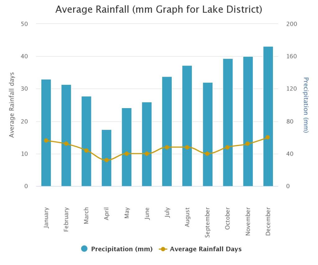
I visited the Lake District during the last week of April 2023 and I had a great time. However, I experienced some drizzle and even some hail: so, you always need to have a rain jacket with you.
Lake District: where to stay
Getting to the Lake District by train, I found it convenient to stay in Windermere, as it is the last railway station of the route. From Windermere you can easily get to the other villages of the Lake District (Ambleside, Grasmere, Keswick…) by bus.
According to accomodation, in Windermere you will have plenty of choices of guesthouses. Just remember to book in advance, in particular if you are planning to visit during the peak season. I stayed at the Briscoe Lodge in Windermere for five nights and had a very good time.
Lake District walks in a day trip from Windermere
So, if you are staying in Windermere, these are some walks you can do in a daytrip, getting around the Lake District National Park by bus.
I recommend always wearing hiking boots and bringing warm clothes with you, as at the top of the fells the weather can dramatically change. Moreover, have some food and water with you, because you won’t find any refreshments once you have left the villages.
Orrest Head
Orrest Head is a beautiful viewpoint at the top of a hill in Windermere. I took this walk on my first day, just to stretch my legs after the journey.
It is an easy walk, as it is 3.5 km (about 2 miles) round trip (the elevation gain is about 130 m). The trail starts just next to the Windermere Hotel, in front of the train station, on the A591 road. You cannot miss it, as a sign marks clearly the path. The route is accessible to wheelchairs too.
The trail enters immediately the wood and, if you are lucky, you might even spot some wildlife: a rabbit (or a hare I am not sure) crossed the path just in front of me.
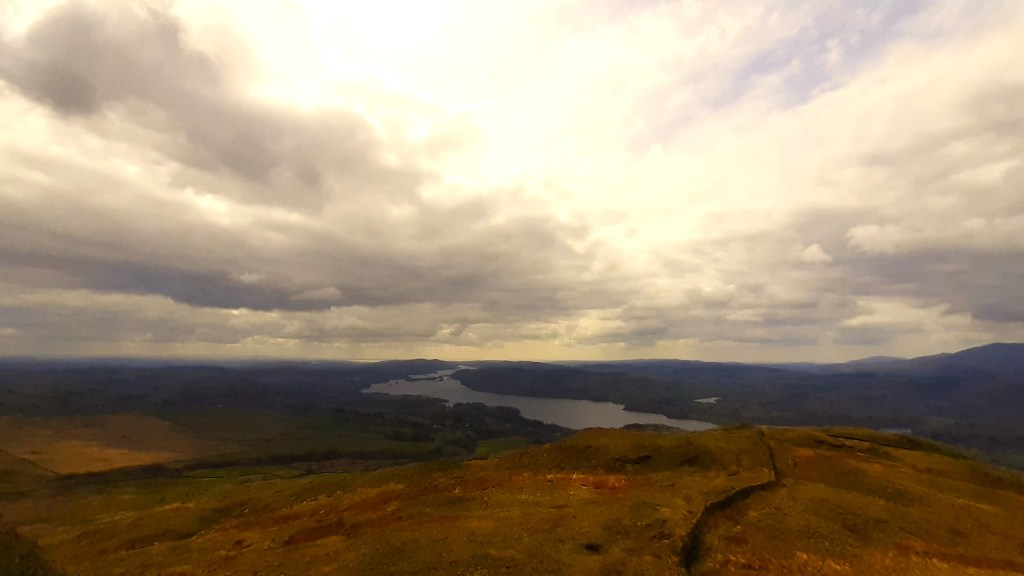
Once you get to the summit, the view is spectacular: you can see the entire Lake Windermere and the fells around it. You will also find some benches to have some rest.

Ambleside, Stock Ghyll Force and Wansfell Pike
Going north along the eastern shore of Windermere on the A591, the first village you meet is Ambleside. From Windermere you can take either the bus 555 or 599 to get to Ambleside.
In Ambleside you will find many cozy pubs where you can relax after your hike. You will also find many outdoor shops!
The first part of this hike, to Stock Ghyll, is quite easy and can be done by anyone reasonably fit. The second part to Wansfell Pike is a bit more challenging, as the trail to the summit of the fell is quite steep. Overall the hike is about 5 km round trip (3 miles) with an elevation gain of 400 m (1300 feet). It took me about 90 minutes.
This trail begins behind the Salutation Hotel in Ambleside: just walk up Stockghyll Lane and follow the directions to the waterfalls. Getting to Stock Ghyll Force took me about 15 minutes. The waterfalls are quite impressive. If you want to rest for a while, you will find some benches here.

From Stock Ghyll Force the way to continue the hike to Wansfell Pike is not very clear. You need to follow a trail to the right that leads you out of the wood back to Stockghyll Lane. Then, after walking uphill for a while, you will find a sign marking a trail to the right, which leads to the top of the fell. The path now gets quite steep, surrounded by green meadows and sheeps grazing. Finally, some stony steps lead to the top.
At the summit of Wansfell Pike, some rocks stick out of the grassy ground and an incredible view shows Lake Windermere and other distant fells hidden by ghostly clouds. Moreover, you can see the typical stony walls stretching across the fells.
At the end of your hike you can spend some time shopping in Ambleside or drinking a beer in one of the pub of the village!
Grasmere, Loughrigg Terrace and Loughrigg Fell
Just a few miles north of Ambleside, Grasmere somehow marks the border between the northern and the southern lakes. From Windermere you can take either the bus 555 or 599 to get to Grasmere.
Grasmere is renowned for being the place where the English poet William Wordsworth spent some years of his life. In addition to the cottage where he lived, in Grasmere you can visit also Wordsworth’s grave in the yard around the church.
From Grasmere you can hike a beautiful loop trail: you can walk along the western shore of the lake and get to Loughrigg Terrace, a lovely spot with a beautiful view over the lake. Then, you can get to the top of Loughrigg Fell and enjoy the incredible scenery. Finally, going back to Loughrigg Terrace, you can finish the loop around the lake and get back to the village of Grasmere. Overall, the hike is about 7.85 km (4.8 miles) and took me about 2 hours; the elevation gain is about 330 m (1082 feet). The only challenging part of the hike is the path from Loughrigg Terrace to the summit of Loughrigg Fell, which is quite steep (the way uphill took me about 40 minutes): if you don’t feel like doing it, you can just skip it and continue the hike from Loughrigg Terrace along the path around the lake.
From the village of Grasmere, you need to take Red Bank Road, which will lead you to the lake. Then, continue walking along the western side of the lake along Red Bank Road, until you find directions to Loughrigg Terrace.

After walking uphill on a short gentle slope through the wood, you get to Loughrigg Terrace, where the trail faces the southern side of the lake and you can enjoy a lovely view of it. Here you will find a bench if you want to rest for a while.
From Loughrigg Terrace you can decide whether to keep on walking on the loop trail around the lake or get to the top of Loughrigg Fell. In the second case you need to take the steep stony steps that start from Loughrigg Terrace. You cannot miss them! Along the way to the summit, the views over the lake are majestic.

Once you get to the top of Loughrigg Fell, a wonderful 360 view encompasses Grasmere, Windermere and other fells. On a sunny day, you can spend some time here relaxing on the green grassy meadows.

From Loughrigg Fell you can go back to Loughrigg Terrace and continue the hike. The last part of the hike is less scenic, as the path crosses the A591 and gets farther from the lake (I highly recommend not walking along the A591). At this point, you may consider to extend the loop around Rydal Water too, if you feel like it.
Finally, you get back to the village and, before taking the bus to Windermere, you can relax for a while with a well-deserved cup of tea and a piece of cake!
Cat Bells
Cat Bells is a fell on the western side of Derwent Water, which is part of the northern lakes. This was definitely the hike I liked the most during my stay in the Lake District.
The name “Cat Bells” comes from the old English word “bield”, which meant “den”, then corrupted to “bells”. In fact, in the past, people used to believe that a wild cat lived on this fell.
The trip from Windermere to Cat Bells is a bit longer than the ones I described before. From Windermere you need to take the bus 555 to Keswick, the main town in the northern lakes, which lies just north of Derwent Water. The bus trip itself is a memorable experience, as the road, surrounded by dramatic fells, is really scenic.
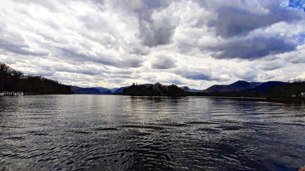
Once you get to Keswick, you need to walk down the Lake Road to Derwent Water (it just takes a few minutes). From here, you need to take the launch to Hawes End, on the western side of the lake. Consider that the boat departs every hour (the ticket was 9.90 £ for the round trip at the time) and remember to check the time of the last ride from Hawes End back to Keswick. The launch trip to Hawes End is really special, as the views from the boat over the surrounding fells and Derwent Island are amazing. Moreover, the utter silence during the voyage creates a magical atmosphere with a mesmerizing effect, which makes the trip unforgettable.
Once you get to Hawes End, you can follow directions to Cat Bells. At the beginning, the trail is quite steep, then it gets gentler in the middle, until the final part which gets quite challenging again. The hike is about 4.5 km round trip (2.8 miles) with an elevation gain of 370 m (1.214 feet): it took me about 90 minutes.
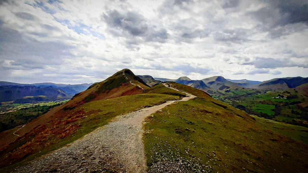
The views along the way from the ridge and from the summit of Cat Bells are spectacular, which makes this hike a classic of the Lake District.

Tarn Hows
Tarn Hows is a small lake located halfway between Hawkshead and Coniston. As it is a little off the beaten track, the only way to get to Tarn Hows is by catching bus 505 to Coniston from Windermere or Ambleside, which is scheduled every hour in the summer.
Tarn Hows offers a lovely circular hike around the lake, which is suitable to anyone. It takes about one hour to walk the loop trail. However, if you plan to get to Tarn Hows by public transport, keep in mind that you will get off the bus either at Hawkshead or Coniston. Then, you will need to walk for a couple of miles to get to Tarn Hows on quite steep roads and paths across moorland.

Did you like this post? Leave a comment below and follow me on social networks to get the latest updates!
If you are interested in other great hikes in England, check out my post about Cornwall!
Lake District, Inghilterra: dove si trova, come arrivare e cosa vedere
Il Lake District si trova nella regione Cumbria nel nord dell’Inghilterra, vicino al confine con la Scozia.
Dopo aver visto su Instagram molte incredibili foto del Lake District, che mostravano paesaggi pittoreschi, laghi incantevoli e cascate impetuose, ero diventato sempre più curioso di questo luogo e così ho deciso di visitarlo. Non avendone mai sentito parlare, ho cominciato a raccogliere informazioni, acquistando una guida per pianificare il viaggio.
Perché visitare il Lake District
Il Lake District è il più grande parco nazionale in Inghilterra: fu inaugurato nel 1951. Il Lake District è famoso per i suoi magici laghi e le sue colline selvagge (fells come le chiamano i locali). È un paradiso per ogni appassionato di trekking, poiché è possibile trovare percorsi per tutti i livelli, sia per principianti, sia per chi ha più esperienza.
Infine, il Lake District è anche ricco di cultura, dal momento che il poeta inglese William Wordsworth trascorse alcuni anni della sua vita nel villaggio di Grasmere. Qui è possibile visitare la sua casa e il suo luogo di sepoltura.
Come arrivare nel Lake District
Il modo più semplice per arrivare nel Lake District è ovviamente in auto, che garantisce più flessibilità negli spostamenti. Ciò nonostante, in alta stagione, visitare il Lake District in auto potrebbe non essere la scelta migliore, a causa dell’elevato traffico. Molte strade infatti diventano congestionate.
Personalmente, sono riuscito a visitare il Lake District utilizzando esclusivamente mezzi pubblici.
Ho preso un volo per Manchester e da lì ho preso il treno per Windermere: a volte è possibile trovare un treno diretto da Manchester a Windermere, ma nella maggior parte dei casi è necessario scendere a Oxenholme e prendere il treno per Windermere. Il viaggio dura fra le due e le tre ore. Prenotando in anticipo, è possibile strappare prezzi assai più bassi e risparmiare. Quindi, sì, è possibile visitare il Lake District in treno!
Come visitare il Lake District senza auto
Una volta arrivati nel Lake District è possibile visitarlo facilmente utilizzando i mezzi pubblici, grazie alla rete di autobus che connette fra loro i villaggi del parco. Spostarsi in autobus per me è stata una bellissima esperienza, poiché permette di godersi gli spettacolari paesaggi durante il viaggio. Inoltre, gli autobus sono sempre puntuali. Bisogna solo fare attenzione che, durante l’inverno (da Novembre a Marzo), alcune rotte sono ridotte o tagliate.
Lake District: quando andare
Il Lake District è spesso considerato come uno dei luoghi più umidi dell’Inghilterra. Di conseguenza, è lecito attendersi qualche precipitazione durante il viaggio.
Mentre durante l’estate sono registrate le temperature più alte e il Lake District diventa piuttosto affollato, secondo i siti di meteorologia Aprile e Maggio sono invece di solito i mesi più secchi nel Lake District e quindi i mesi migliori in cui andare.
Ho visitato il Lake District nell’ultima settimana di Aprile del 2023 e complessivamente il tempo è stato più che buono. Ho sperimentato comunque qualche leggera pioggia e in una occasione pure una grandinata: è d’obbligo quindi avere sempre a portata di mano una giacca impermeabile.
Lake District: dove alloggiare
Arrivando nel Lake District in treno, ho trovato comodo alloggiare a Windermere, essendo il capolinea della linea ferroviaria. Da Windermere è possibile raggiungere facilmente altri villaggi del Lake District (Ambleside, Grasmere, Keswick…) in autobus.
Relativamente a dove alloggiare, a Windermere è presente un’ampia scelta di guesthouse. È importante ricordarsi di prenotare in anticipo, soprattutto nel caso si visiti il Lake District durante l’alta stagione. Ho soggiornato al Briscoe Lodge di Windermere e ho avuto un’ottima esperienza.
Percorsi trekking nel Lake District in giornata da Windermere
Se alloggi a Windermere, questi sono alcuni percorsi di trekking perfetti per una gita in giornata, spostandosi all’interno del Lake District in autobus.
Consiglio di indossare sempre scarpe da trekking e portare abbigliamento caldo, poiché sulla cima delle colline il tempo può cambiare in modo repentino. Inoltre, è bene avere sempre una buona scorta di acqua e cibo poiché non è più possibile trovare luoghi dove rifocillarsi una volta abbandonati i villaggi.
Orrest Head
Orrest Head è uno splendido punto panoramico sulla cima di una collina nei pressi di Windermere. Ho fatto questa passeggiata il mio primo giorno, giusto per sgranchire le gambe dopo il viaggio.
È una camminata facile di 3,5 km andata e ritorno con un dislivello di circa 130 m. Il sentiero inizia proprio accanto al Windermere Hotel, di fronte alla stazione ferroviaria, sulla strada A591. È quasi impossibile mancarlo, poiché il sentiero è ben marcato dalla segnaletica. Il percorso è accessibile anche per le sedie a rotelle.
Il sentiero si addentra fin da subito nel bosco e, se si è fortunati, è possibile anche avvistare qualche esemplare di fauna selvatica: un coniglio (o forse una lepre, non ne sono certo) ha attraversato il sentiero proprio davanti a me.
Una volta arrivati in vetta, la vista è spettacolare: è possibile ammirare l’intero lago Windermere e le colline circostanti. In cima si trovano anche delle panchine su cui fermarsi qualche minuto.
Ambleside, Stock Ghyll Force e Wansfell Pike
Andando verso nord lungo la costa orientale del lago Windermere sulla A591, il primo villaggio che incontriamo è Ambleside. Da Windermere è possibile prendere l’autobus 555 o 599 per raggiungere Ambleside.
A Ambleside si trovano molti pub accoglienti dove è possibile rilassarsi dopo una camminata. Ci sono anche molti negozi di abbigliamento e accessori da trekking.
La prima parte di questo trekking (fino a Stock Ghyll) è piuttosto semplice e può essere fatta da chiunque sia un minimo in forma. La seconda parte fino a Wansfell Pike è invece un po’ più sfidante, poiché il sentiero per la cima della collina è piuttosto ripido. Complessivamente il trekking è lungo circa 5 km andata e ritorno con un dislivello di circa 400 m. Ho impiegato circa 90 minuti a percorrerlo.
Il sentiero inizia dietro il Salutation Hotel a Ambleside: basta camminare lungo Stockghyll Lane e seguire le indicazioni per le cascate (waterfalls). Per arrivare a Stock Ghyll Force ho impiegato circa 15 minuti. Le cascate sono piuttosto impressionanti. Anche qui sono presenti delle panchine per fermarsi qualche minuto.
Da Stock Ghyll Force la via per proseguire il trekking fino a Wansfell Pike non è molto chiara. Bisogna seguire un sentiero sulla destra che conduce fuori dal bosco e riporta sulla Stockghyll Lane. Quindi, dopo aver camminato per un breve tratto in salita, si trova un sentiero sulla destra che conduce alla vetta della collina. Il sentiero ora diventa piuttosto ripido ed è circondato da prati verdi con pecore al pascolo. Infine, dei gradini di pietra portano alla cima.
La vetta di Wansfell Pike è caratterizzata da rocce che spuntano dal terreno erboso e da un bellissimo panorama che spazia sul lago Windermere e le colline circostanti, spesso velato da nuvole quasi spettrali. In lontananza è possibile osservare anche i tipici muretti in pietra che si dispiegano attraverso le colline.
Al termine del trekking è possibile concludere la giornata facendo un po’ di shopping a Ambleside o godendosi una meritata birra in uno dei pub del villaggio!
Grasmere, Loughrigg Terrace e Loughrigg Fell
A pochi chilometri a nord di Ambleside, Grasmere segna in qualche modo il confine fra i laghi meridionali e settentrionali. Da Windermere è possibile prendere gli autobus 555 o 599 per arrivare a Grasmere.
Grasmere è famosa per essere il luogo dove il poeta inglese William Wordsworth trascorse alcuni anni della sua vita. Oltre al cottage dove visse, a Grasmere è possibile visitare la tomba di Wordsworth situata nel giardino intorno la chiesa.
Da Grasmere è possibile percorrere un bellissimo percorso di trekking ad anello: camminando lungo la sponda occidentale del lago, si arriva a Loughrigg Terrace, un incantevole punto panoramico con vista sul lago. Da qui, si può salire fino alla cima di Loughrigg Fell e godersi l’incredibile vista. Infine, tornando indietro a Loughrigg Terrace, si conclude l’anello intorno al lago e si torna al villaggio di Grasmere. Complessivamente, il percorso è lungo circa 7,85 km (ho impiegato circa 2 ore); il dislivello è circa 330 m. L’unica parte particolarmente dura del percorso è il tratto fra Loughrigg Terrace fino alla cima di Loughrigg Fell, essendo piuttosto ripido (ho impiegato circa 40 minuti per la salita): se non ci si sente di intraprendere questo tratto, si può semplicemente tirare dritto a Loughrigg Terrace e continuare il percorso intorno al lago.
Dal villaggio di Grasmere, bisogna prendere Red Bank Road, che conduce al lago. Quindi, si continua a camminare sulla sponda ovest del lago fino a Red Bank Road, finché non si trovano le indicazioni per Loughrigg Terrace.
Dopo una breve salita attraverso il bosco, si arriva a Loughrigg Terrace, dove il sentiero si affaccia sul lato meridionale del lago e da dove è possibile godere di una piacevolissima vista. Qui ci si può rilassare qualche minuto su una panchina.
Da Loughrigg Terrace si può decidere se continuare il percorso ad anello intorno al lago o salire fino alla cima di Loughrigg Fell. Nel secondo caso bisogna salire lungo i ripidi scalini di pietra che iniziano da Loughrigg Terrace: è impossibile mancarli! Lungo la via verso la vetta, le viste sono magnifiche.
Una volta arrivati a Loughrigg Fell, si spalanca uno stupendo panorama a 360 gradi verso Grasmere, Windermere e altre colline. In una giornata di sole ci si può rilassare per un po’ sui verdi prati.
Da Loughrigg Fell si torna indietro a Loughrigg Terrace e si continua il percorso. L’ultima parte del trekking è meno panoramica, poiché il sentiero attraversa la strada A591 e si allontana dal lago (consiglio caldamente di non camminare lungo la A591). A questo punto, uno può valutare di estendere l’anello intorno a Rydal Water.
Infine, si torna al villaggio e, prima di riprendere l’autobus per Windermere, ci si può rilassare con una tazza di tè e un pezzo di torta!
Cat Bells
Cat Bells è una collina sul lato occidentale di Derwent Water, che fa parte dei laghi settentrionali. Questo è senza dubbio il trekking che mi ha emozionato di più durante il mio viaggio nel Lake District.
Il nome “Cat Bells” deriva dall’antica parola inglese “bield“, che significava “den” (ovvero tana in italiano), poi storpiato in “bells“. Infatti, in passato, era una credenza popolare che un gatto selvatico vivesse su questa collina.
Il viaggio da Windermere a Cat Bells è un po’ più lungo rispetto a quelli descritti in precedenza. Da Windermere si prende l’autobus 555 per Keswick, la città principale dei laghi del nord, che si trova poco a nord di Derwent Water. Il viaggio in autobus lungo la strada panoramica circondata da imponenti colline è di per sé un’esperienza memorabile.
Una volta arrivati a Keswick, bisogna camminare lungo la Lake Road fino a Derwent Water (ci vogliono pochi minuti). Da qui si prende quindi la barca per Hawes End, sulla sponda occidentale del lago. Teniamo in mente che la barca parte ogni ora (il biglietto costava 9,90 £ andata e ritorno al momento del viaggio); è importante anche prendere nota dell’orario di partenza dell’ultima barca da Hawes End a Keswick. Il viaggio in barca verso Hawes End è veramente speciale: la vista dalla barca verso le colline e Derwent Island sono incredibili. Inoltre, il totale silenzio durante il viaggio crea una sorta di atmosfera magica, con un effetto quasi ipnotico, che rende la traversata indimenticabile.
Arrivati a Hawes End, si seguono le indicazioni per Cat Bells. All’inizio, il sentiero è piuttosto ripido, per poi essere più dolce nella parte centrale, fino all’ultimo tratto dove diventa di nuovo più impegnativo. Il percorso è lungo circa 4,5 km andata e ritorno con un dislivello di 370 m: ho impiegato circa 90 minuti.
I panorami lungo il crinale e dalla vetta di Cat Bells sono spettacolari e fanno sì che questo trekking sia uno dei più iconici del Lake District.
Tarn Hows
Tarn Hows è un piccolo lago situato a metà strada fra Hawkshead e Coniston. Essendo un po’ fuori mano, l’unico modo per arrivare a Tarn Hows è prendere l’autobus 505 per Coniston da Windermere o Ambleside, che è programmato ogni ora durante l’estate.
Tarn Hows offre una piacevole passeggiata ad anello intorno al lago, adatta per tutti. Occorre circa un’ora per completare il percorso. Comunque, se intendiamo arrivare a Tarn Hows con i mezzi pubblici, bisogna tenere a mente che le fermate dell’autobus sono a Hawkshead o Coniston. Si deve quindi camminare per circa tre chilometri per arrivare a Tarn Hows su strade abbastanza ripide e sentieri attraverso la brughiera.
Ti è piaciuto questo articolo? Lascia un commento qui sotto e seguimi sui social networks per non perdere gli ultimi aggiornamenti!
Se sei interessato\a ad altri trekking in Inghilterra, dai un’occhiata all’articolo sul mio viaggio in Cornovaglia!

One thought on “Lake District National Park: walks and day trips from Windermere”