Disclosure: this post contains affiliate links: I will earn a small commission, if you make a purchase through these links, without any additional cost to you.
There are some trips that you have been dreaming about since you were a child. This is one of them. I have been dreaming for years to travel through US National Parks, feel the adrenaline to drive along legendary roads like Route 66, visit epic places like Grand Canyon or Monument Valley that have been the location of so many famous movies. It is definitely the trip of a lifetime and I finally had the opportunity of taking this journey back in 2014.
It goes without saying that the best way to get the most out of this trip is to rent a car and enjoy the drive along these incredible scenic roads. That was what my friends and I did: we rented our cars in San Francisco (California) and dropped them off in Denver (Colorado) 15 days later. By the way, read my post about how to rent a car and save.
During this journey you will experience incredible emotions all the time: you will be mesmerized by the beauty of the ocean, the majesty of the mountains in Yosemite National Park, the endless road through Death Valley National Park, the lights of Las Vegas, the immensity of Grand Canyon, the magic of Antelope Canyon and the wonderful Monument Valley.
So, let’s see the itinerary I followed in this iconic road trip: are you ready to experience the dream?
Time zones in Western US
Since you will often cross the border between different States, you will have to adjust to different time zones continuously! California and Nevada are in the Pacific Time Zone (which means that they are 9 hours behind Rome and Paris for instance). Utah and Colorado are instead in the Mountain Time Zone, which is one hour ahead California. However, all these States observe daylight saving time. You get really crazy when you travel through Arizona, which is in the Mountain Time Zone, but it does not observe daylight saving time. That means that during the summer Arizona is in the same time zone as California, while, during the winter, the time in Arizona, Utah and Colorado is the same. It is not over yet! In Arizona the Navajo Nation observes daylight saving time: so, you will have to adjust to different time zones in the same State!
So, I try to sum it up: if you go on this road trip in the summer, the time will be the same in California, Nevada and Arizona, while Utah, Colorado and the Navajo Nation (in Arizona) will be one hour ahead. Got it?
Weather in Western US
During your trip you will go through very different weathers. Along the coast of California the weather will be mild, while it will get definitely hot in Death Valley and in Las Vegas. On the contrary, when you travel through the mountains in Utah and in Colorado, temperatures will drop and it can be as cold as 10°C (50°F) even in the summer. Then, be ready to bring different kinds of clothing in your luggage!
Where to start a road trip through Western US National Parks
As I mentioned above, we started our road trip in San Francisco and finish it in Denver. Of course, there are many other combinations and you should adjust it to your own preferences. Other good possible starting points can be Los Angeles, Las Vegas or Phoenix: it depends on which areas you are most interested in and on how much time you have got. For instance, you may wish to extend your trip and drive along the coast of Southern California: if so, read my post about the best beaches in Southern California.
The U.S. Park Pass
If you are going to visit different National Parks during your road trip, I definitely recommend buying the U.S. Park Pass.
The U.S. Park Pass grants you access to all American National Parks: Grand Canyon, Yosemite and Arches are included for instance! It is valid for a year and it is much cheaper than paying the single entrance fees to National Parks one at a time. In fact, while the annual pass is 80 $, a single entrance to a park is 35$ per vehicle. So, if you are going to visit at least three parks, purchasing the annual pass is absolutely great value for money.
Unfortunately, landmarks located in the Navajo Nation are not included in the pass, like Antelope Canyon and Monument Valley.
My itinerary through Western US National Parks
This is the itinerary of our road trip. On the map I marked the major spots of our journey: they don’t necessarily correspond to a single day and they are not exhaustive of all the places we visited. In particular, I marked the set of points that let Google draw the most truthful path compared to the one we actually followed (for the maths lovers, it was a sort of operations research problem, as you cannot add more than 10 points…). In fact, our trip lasted about two weeks, as we arrived in San Francisco on August 10th and departed from Denver on August 25th. Overall, we drove for over 4.000 km (2.485 miles).
- A: San Francisco
- B: Pfeiffer Big Sur State Park
- C: Bodie State Historic Park
- D: Badwater Basin, Death Valley
- E: Grand Canyon National Park
- F: Bryce Canyon National Park
- G: Monument Valley
- H: Durango
- I: Arches National Park
- J: Denver
Honestly, looking back on it, perhaps I would leave something out and spend more time in other places in order to better appreciate them. It was a quite tight schedule for two weeks. As I discussed in my post about slow travel, it is not about seeing places: it is about feeling emotions. At the end of our journey we were quite exhausted, but, nonetheless, happy for the memorable trip we had that we would never forget. Six years have passed now, but we keep talking about those memories and the epic moments we had together.
Let’s now see the itinerary in detail.
San Francisco
San Francisco was the first stop of our road trip: we arrived in the evening after a long flight from Munich. We spent two nights in the city.
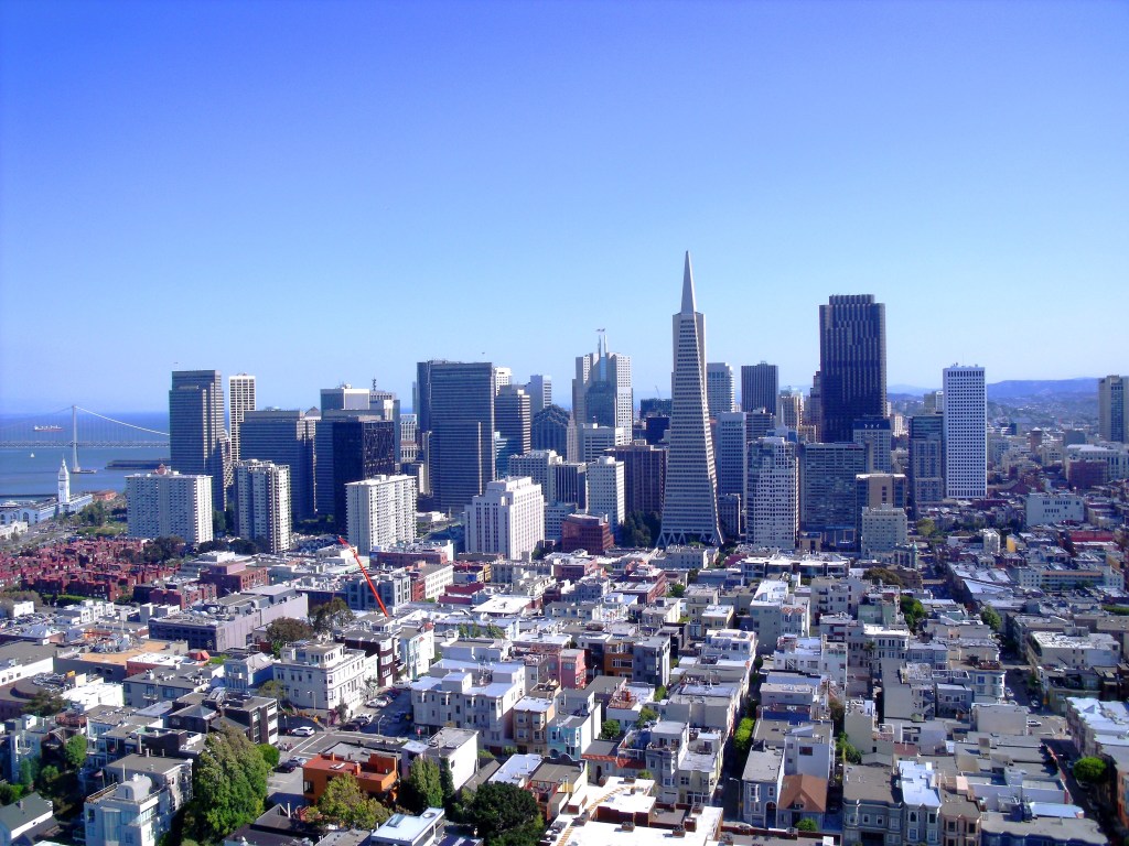
San Francisco is located in the north of California on the coast; walking along the streets of San Francisco is real exercise, as there are a lot of steep uphill streets. The most famous of them is definitely Lombard Street, known as “the crookedest street in the world“!

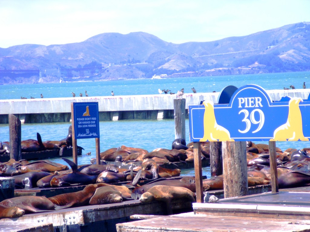
Another must-see place in San Francisco is Fisherman’s Wharf, a neighborhood in the north of the city, and in particular the iconic Pier 39, where you can taste the typical crab chowder in a bread bowl. From here you can enjoy beautiful views over San Francisco Bay. Moreover, you will have the opportunity to see sea lions closely, as they love lying on the docks in the sun.
If you wish to have a great view over the city, don’t miss to visit the Coit Tower in the Telegraph Hill neighborhood.
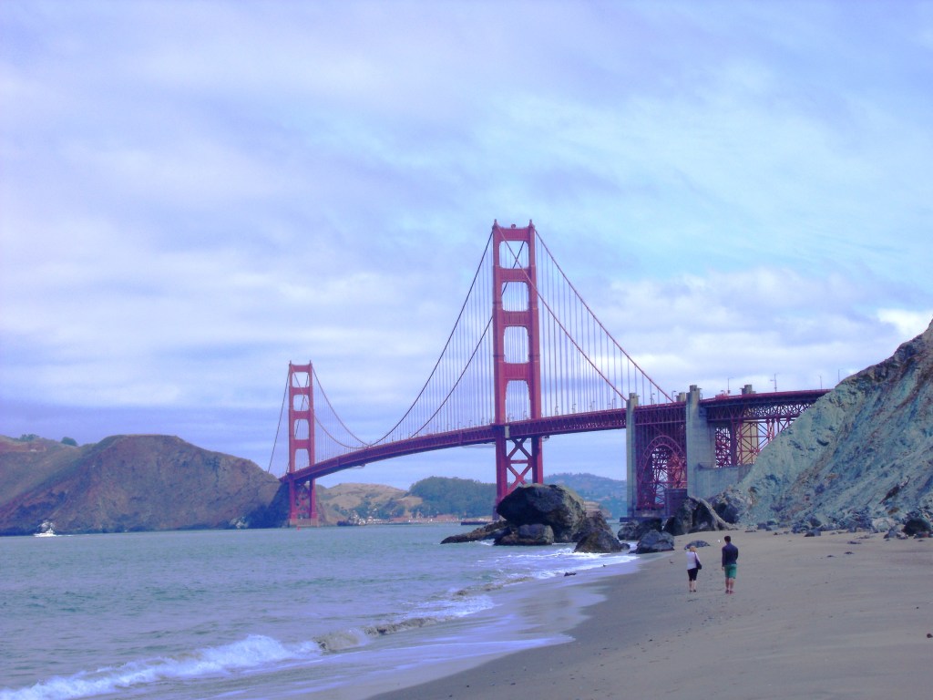
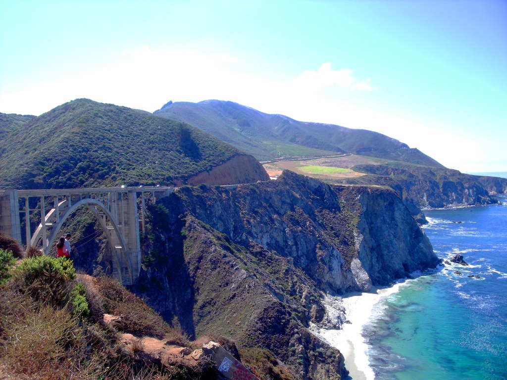
Last, but not least, you can’t end your visit to San Francisco without seeing the world-famous Golden Gate Bridge closely, the true symbol of the city, with a main span of 4,200 feet (1,280 m). I definitely recommend taking a hike along the coastal trail on the cliffside that begins from the bridge itself and that leads to Baker Beach, from where you can enjoy a great view over the Golden Gate Bridge.
Driving along the Pacific Coast Highway: Monterey, Carmel-by-the-Sea, Pfeiffer Big Sur State Park
After visiting San Francisco, we headed south along the iconic Pacific Coast Highway, also known as Highway 1. As I have already said on my post about the best beaches in Southern California, this is one of the most beautiful scenic roads in the world. Make sure to drive the Pacific Coast Highway from north to south: this way you will be driving on the lane closer to the ocean and the views will be much better. Make sure to stop at the viewpoints along the way and enjoy the amazing views from the cliffs over the wild beaches and the ocean.
We spent the night in Monterey, a small town on the coast. The next day we hit the road again and visited Carmel-by-the-Sea, another beautiful small town by the ocean, and the wonderful Big Sur area, including the Bixby Creek Bridge and Julia Pfeiffer Burns State Park (don’t miss the McWay Falls).
Then, it was time to leave the coast: we headed to Fresno to spend the night. It was the beginning of our journey into the very heart of the American Southwest.
Yosemite National Park
After getting up early in the morning, we headed to Yosemite National Park. Located mostly in the Mariposa County, in the western Sierra Nevada, Yosemite National Park is famous for its giant sequoia groves, granitic peaks, waterfalls and lakes.
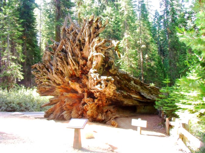
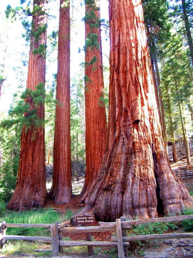
Our first stop was Mariposa Grove, a beautiful grove of giant sequoias: here, you can take a hike following different trails. We took the Grizzly Giant Loop Trail, a 2-mile path. Along the way we had the opportunity to see some iconic landmarks of the park, such as the Fallen Monarch, the Bachelor and Three Graces, the Grizzly Giant and the California Tunnel Tree. You will be amazed by the immense size of these trees!


After the walk, we resumed our trip and we drove across the park along State Route 120, also known as Tioga Road, a wonderful scenic road, that finally leads to the Tioga Pass at 9,945 feet (3,031 m). Keep in mind that this road is open just in the summer, owing to the heavy snowfalls occurring during the rest of the year. Along the way you will enjoy beautiful views over the mountains surrounding you.

Bodie
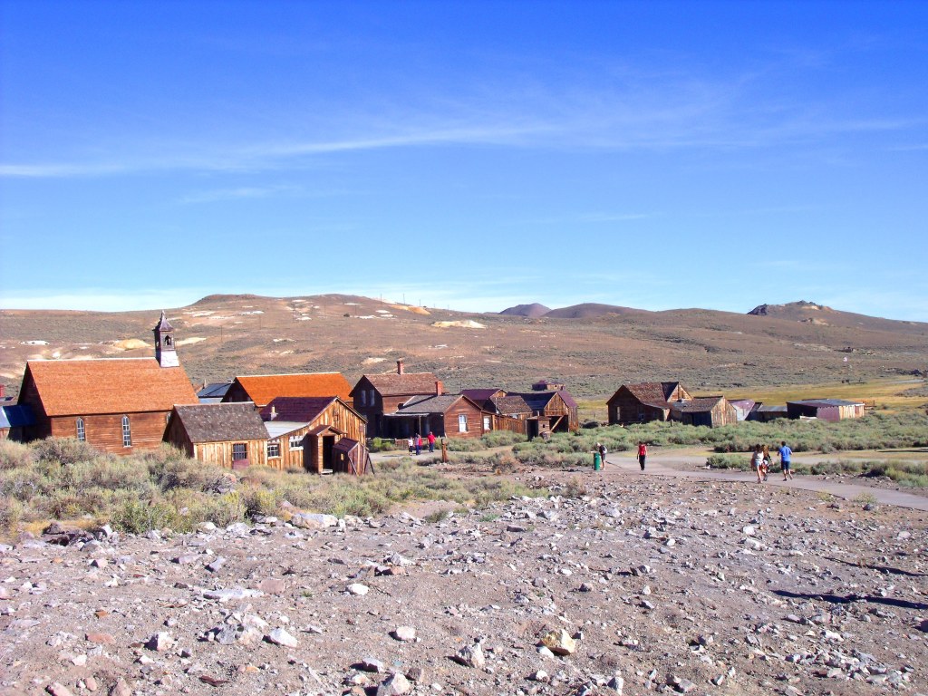
After leaving Yosemite National Park, we had a small detour to north to Bodie, a ghost town. At the end of the Tioga Road, just take Highway 395 north and then turn right onto State Route 270, also known as Bodie Road. A visit to this place will make you feel like being back in the legendary Far West. Originally a mining camp with a population of 10,000 people in 1879, Bodie went into a slow decline in the following years and was then progressively abandoned. Today, Bodie is part of Bodie State Historic Park and it is preserved as it was in the 19th century. Wandering along its empty streets, you will have the opportunity to see the old buildings of the town, like the church or the saloon: you can even enter them! It is definitely worth the visit.
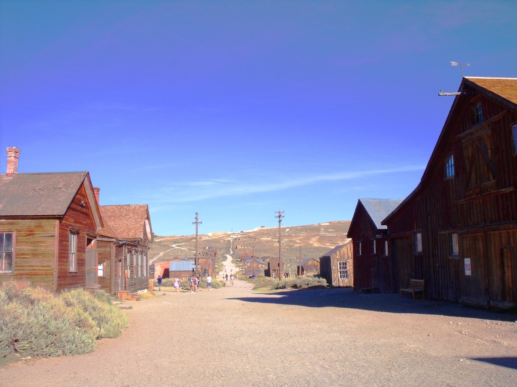
After visiting Bodie, we headed south along Highway 395 and we spent the night in Bishop, ready to explore Death Valley the next day.
Death Valley National Park
This was one of the longest stages of our road trip. From Bishop we kept going south along Route 395 and then took State Route 190 to drive through Death Valley National Park. Death Valley is a vast basin below sea level, famous for being one of the driest and hottest places on Earth. A few stats: Badwater Basin is the lowest point in North America (- 282 feet, – 85.5 m) and Death Valley holds the record for the highest temperature ever recorded on Earth (134° F, 56° C), set in July 1913. It is definitely a place of extremes!
Driving along the road through Death Valley National Park is definitely amazing. You will see desert landscapes that look like they are from another planet: to get to Badwater Basin you need to turn right onto Badwater Road after Furnace Creek. You can enjoy a wonderful view over Badwater Basin from Dante’s View (you need to get back on Route 190 and then take Furnace Creek Wash Road): it is named after the Italian poet Dante Alighieri, as Death Valley reminds of Hell, as described in his work. You can see the huge salt deposits, a memory of the lake that millions of years ago was here. Finally, another great viewpoint is Zabriskie Point along Route 190.


Then we resumed our trip and, after a long drive, eventually in the late afternoon we got to fabulous Las Vegas, where we spent one night.
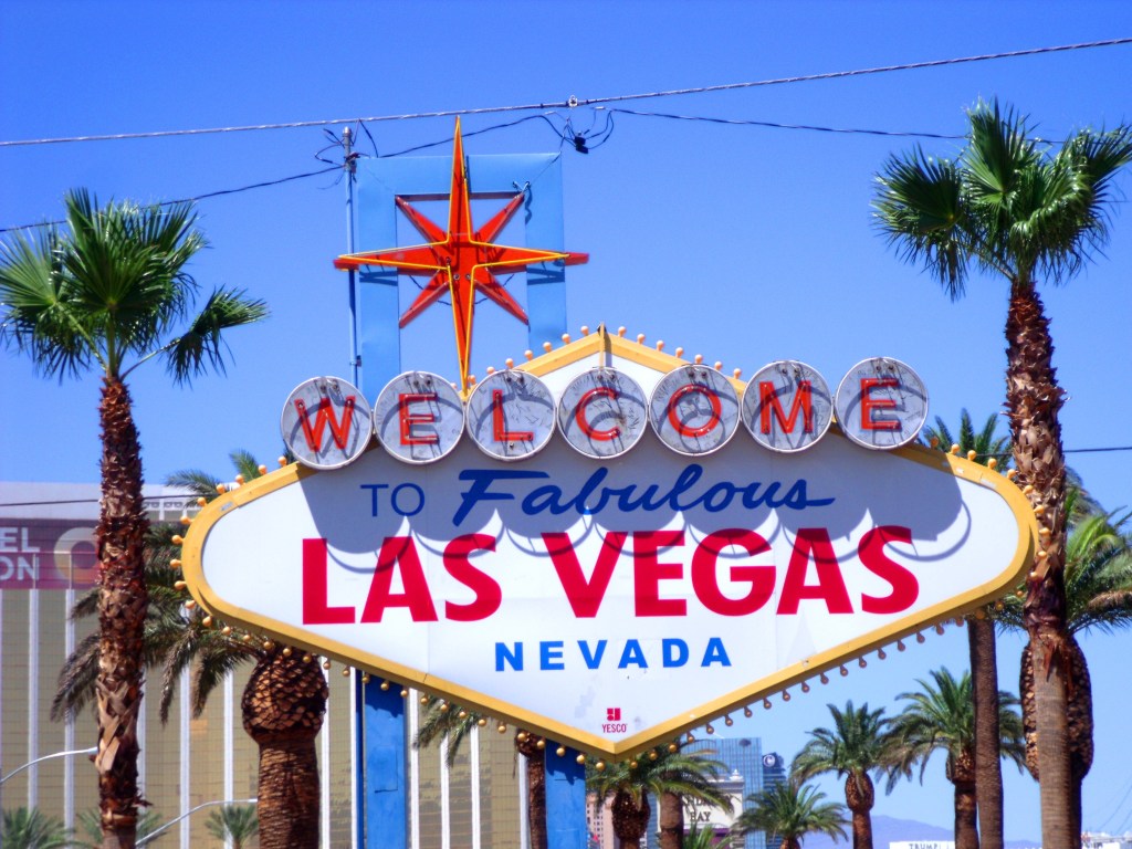
Las Vegas
Las Vegas (we are now in Nevada) appears literally out of nowhere while you are driving in the desert. You will see its skyscrapers coming out in the distance as if by magic.
Las Vegas is renowned all over the world as the Capital of Entertainment, thanks to its mega hotels and casinos open 24/7. It goes also by the name of “Sin City“.
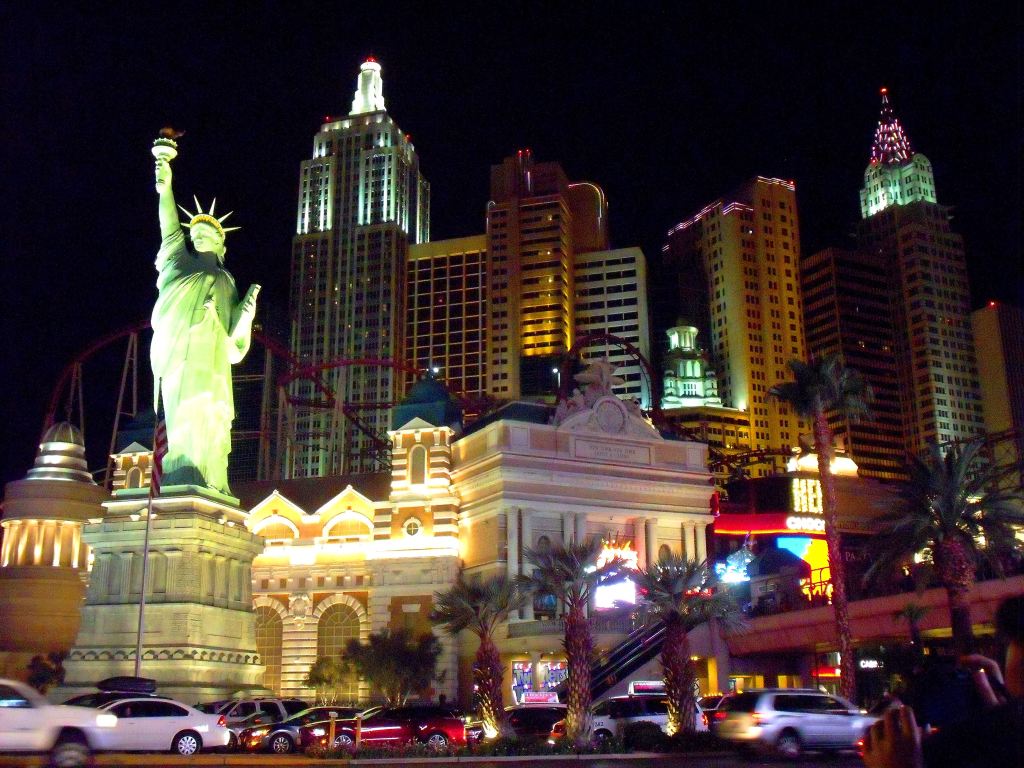
Symbol of the city is definitely The Strip, the 4-mile boulevard where the major hotels are located: you will be mesmerized by its bright lights in the night! Walking along The Strip you will have the opportunity to see reproductions of the Tour Eiffel, the Statue of Liberty, an Egyptian pyramid, Camelot, the Venice canals and a Roman palace! It is definitely a one of a kind city!
In my opinion, if you decide to spend a night in Las Vegas, I definitely recommend that you stay in one of the iconic hotels along The Strip, as it is part of the experience itself. They are less expensive than you might think. We spent the night at the Bellagio Hotel: I felt like being in the set of Ocean’s Eleven, the 2001 movie featuring George Clooney, Brad Pitt and Julia Roberts! It was an incredible moment! Whether you stay at the Bellagio or not, don’t miss the spectacular Bellagio Fountain Show!


Driving along Historic Route 66
In the next day, we continued our trip and we entered Arizona. We made a first stop at Oatman, a ghost town along Historic Route 66. Oatman is a typical Far West town and, unlike Bodie, is still alive. It is famous for its burros wandering free in the village. It is definitely worth a visit if you wish to relive the Old West! The town was named after Olive Oatman, a young girl enslaved by Indians.

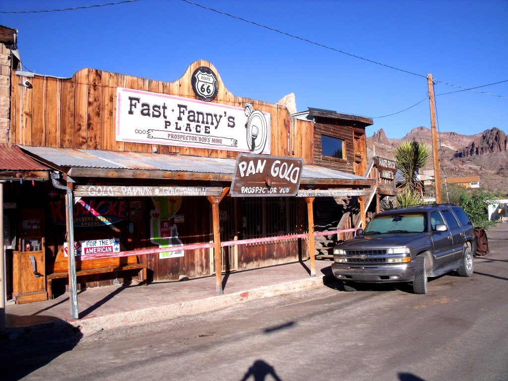
Then, we kept driving east along Interstate 40 and, after another stop at Kingman where we joined a typical local festival, we finally got to Williams, where we were going to spend the next two nights.
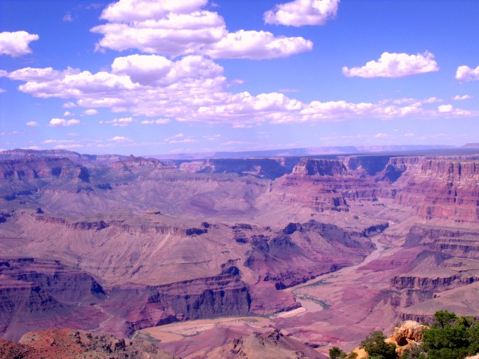
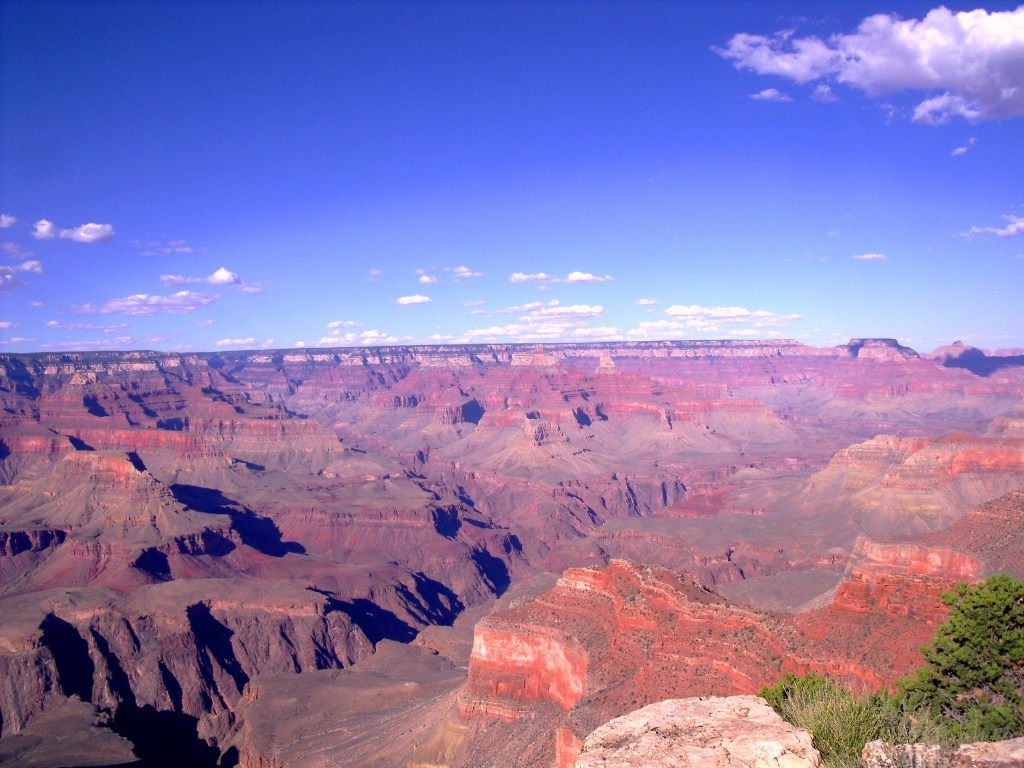
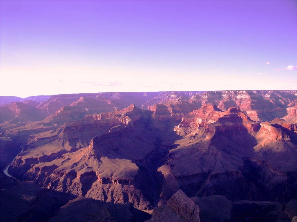
Grand Canyon National Park
Grand Canyon was one of the biggest attractions we visited during our trip. It is famous all over the world and it is a true icon of the American Far West. Grand Canyon is in fact one of the most visited places in the United States with millions of visitors every year. It is part of Grand Canyon National Park.
Grand Canyon is a huge canyon carved by the Colorado River in millions of years in Arizona. It is 277 miles (446 km) long, a mile (1.6 km) deep and up to 18 miles (29 km) wide (data from National Park Service): it is indeed a majestic masterpiece of nature. Not surprisingly, Arizona’s nickname is “The Grand Canyon State”.
The South Rim is definitely the most popular side of Grand Canyon. You can start your visit from the South Rim Visitor Center and then enjoy the amazing viewpoints on the road along the rim. If you have more time, you can considerate more active things to do as well, like hiking or rafting for instance. If you wish to stay overnight, I recommend booking in advance, as far ahead as possible. As I mentioned above, we stayed in Williams, a small town along the US Route 40, a one-hour drive from Grand Canyon.
Staring into the immensity of this natural wonder will definitely make you breathless.
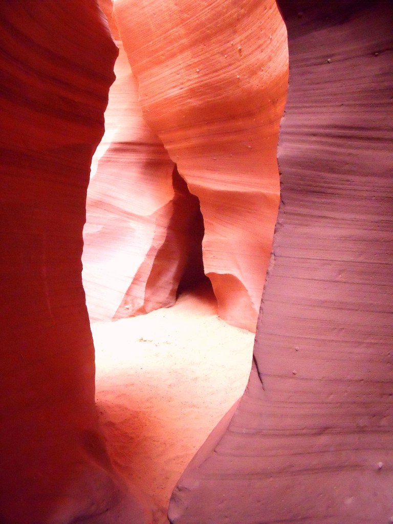
Lower Antelope Canyon
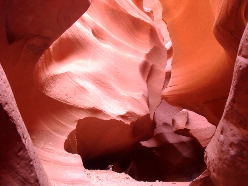
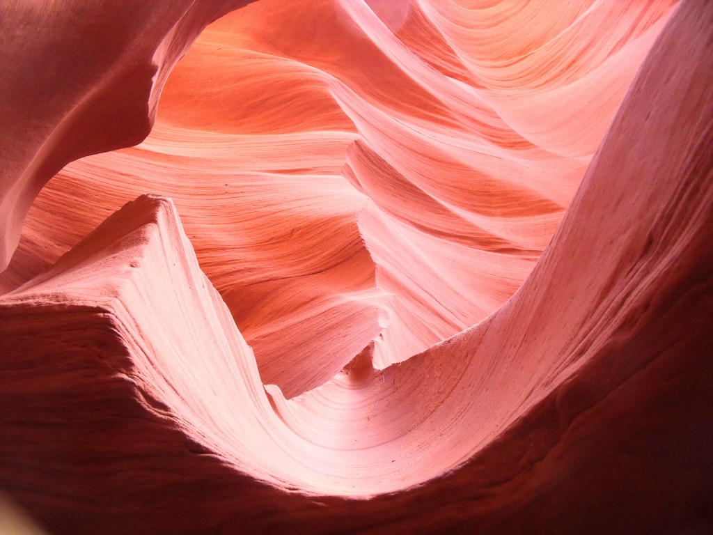
The next day we left Williams and we drove northwards along Route 89. Our first stop was Antelope Canyon. Though it may not be as famous as other landmarks in the American Southwest, I definitely recommend visiting this place: it was my favourite one, as it was a really emotional experience. As it is part of the Navajo Nation, the entrance is not included in the U.S. Park Pass and only guided tours are allowed. Antelope Canyon takes its name from old Navajo stories about antelopes grazing in this area.
Antelope Canyon actually includes two different canyons, Lower Antelope Canyon and Upper Antelope Canyon (we visited the first). They are deep and very narrow canyons, famous for their sandstone shaped like waves, which makes it a one-of-a-kind natural wonder: this is the result of water erosion in millions of years. In particular, the beams of sunlight penetrating into the canyon from above create a unique magical atmosphere. You get to the bottom of the canyon by several flights of steep stairs. Then, walking along the narrow path among these incredible wave-like rocks will definitely makes you breathless.

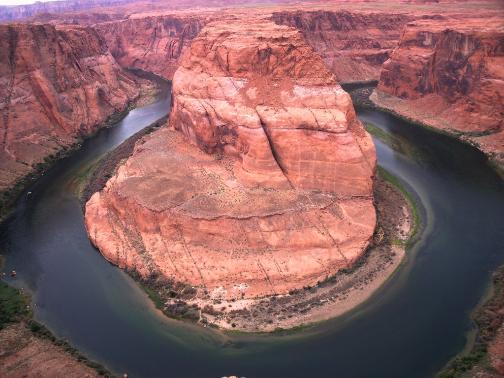
Horseshoe Bend
Located just a few minutes drive from Antelope Canyon along US Route 89, Horseshoe Bend is a world-famous wonderful viewpoint over the Colorado River. It is another masterpiece of nature you don’t want to miss. Unfortunately, recently an entrance fee has been introduced.
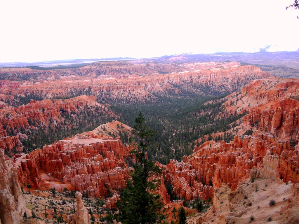
Bryce Canyon National Park
We then kept driving north along US Route 89 and in the late afternoon we got to Bryce Canyon National Park and we had a first glimpse of this awesome canyon from the several viewpoints along the road. We were now in Utah and, given the high elevation (8,300 feet; 2,530 m), the weather had become cooler. Utah’s slogan in fact is “Life elevated”.
Bryce Canyon is famous for its unique endless fields of red rock pillars, called hoodoos, which will definitely bewitch you. Furthermore, the contrast between the dark green forest and the red rocks surrounding it makes the landscape even more spectacular. Bryce Canyon was named after the Scottish pioneer Ebenezer Bryce who settled in this area in the late 19th century.

After spending the night in Panguitch, the next day we had a great hike through Bryce Canyon, which gave us the opportunity to see it from a different point of view. I definitely recommend this hike, because walking among the hoodoos makes you feel how tall they are.
Finally, hiking through the park you can also have the oppurtunity to have close encounters with wildlife! Please, do not feed them!

Hite Overlook
Then we left Bryce Canyon National Park and hit the road again. We took a long detour north along Utah State Route 12 (also known as Utah’s Scenic Byway 12) and Utah State Route 95 (also known as Utah’s Bicentennial Highway Scenic Byway). They are two beautiful scenic roads. Utah’s Scenic Byway 12 is also nicknamed “A Journey Through Time Scenic Byway”.
A not-to-be-missed viewpoint along Utah State Route 95 is Hite Overlook. From here you can have a wonderful view over the Colorado River and the Hite Crossing Bridge.

Monument Valley
Our next stop was another memorable moment, one of the most long-awaited of our road trip. Monument Valley is a legendary icon of the American Southwest. It has been the set of so many famous movies, like “Stagecoach” and “The Searchers”. Its sandstone red towers (buttes) are part of popular imagination.
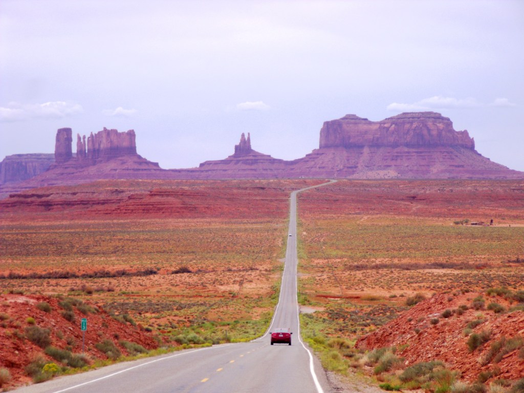
Monument Valley is located on the border between Utah and Arizona and it is part of the Navajo Nation. You can drive yourself along the 17-mile scenic road through Monument Valley or you can join an escorted tour by Navajo guides. Two of the most popular viewpoints in Monument Valley are John Wayne’s Point (at the Visitor Center) and John Ford’s Point.


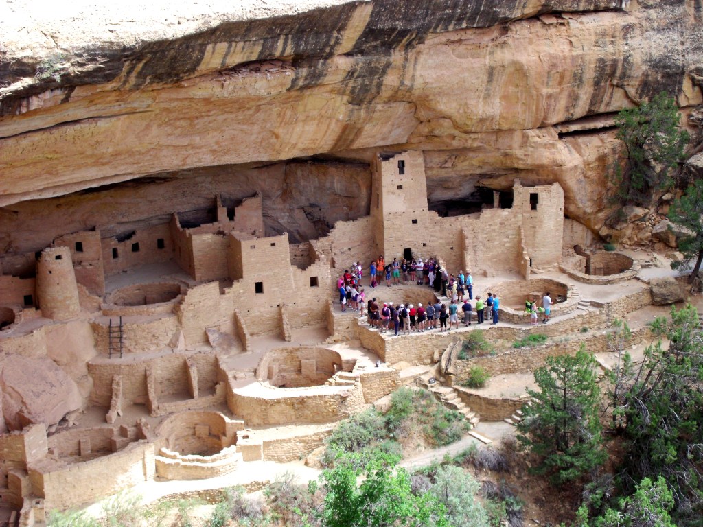
Mesa Verde National Park
We then headed to Colorado. After a quick stop at the Four Corners Monument, which marks the intersection between the borders of Utah, Arizona, New Mexico and Colorado, we visited Mesa Verde National Park.
Mesa Verde National Park is a UNESCO World Heritage Site and it preserves the dwellings of the Ancestral Puebloans, dating back between 700 and 1300. We finally spent the night in Durango.
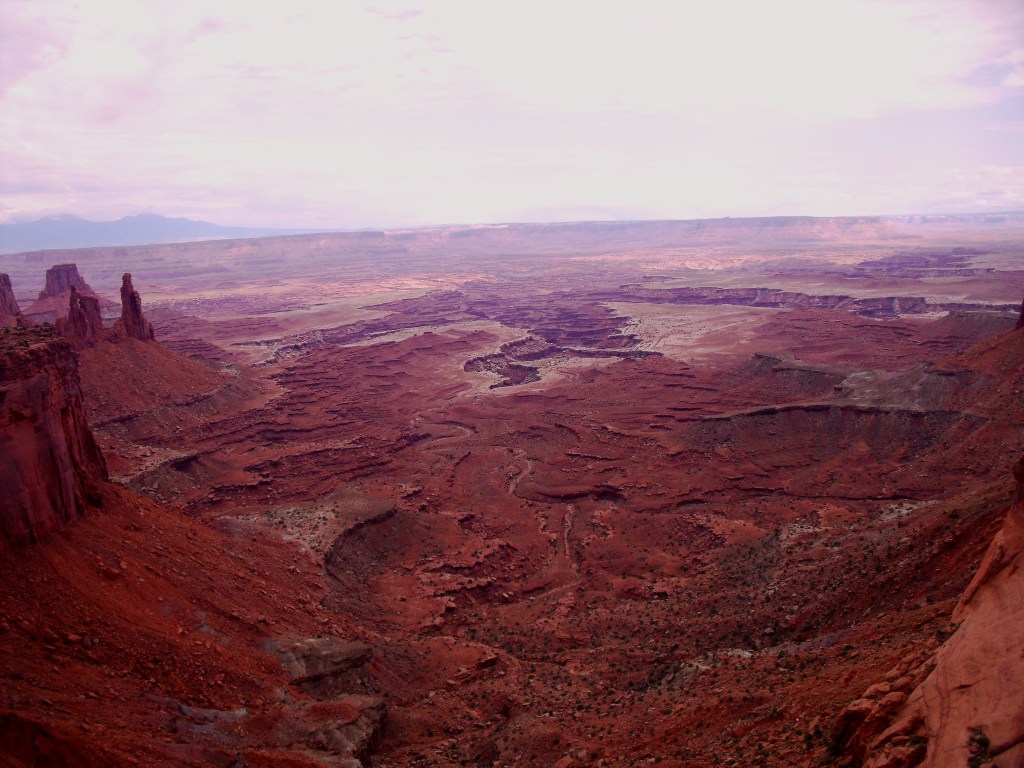
Canyonlands National Park
After the detour to Colorado, we got back to US Route 191 and continued our journey northwards. Our next stop was Canyonlands National Park in the Moab area, where we would spend the night later.
Canyonlands National Park is an endless land of canyons carved in millions of years by the Colorado River and its tributaries. The park is divided in four districts, the most famous of which is Island in the Sky that is also the easiest to access. Here you will enjoy dramatic views over Canyonlands’ amazing landscape that will definitely make you breathless: Mesa Arch and Grand View Point are easily accessible with a short hike.

Dead Horse Point State Park
Close to Canyonlands National Park, Dead Horse Point State Park is another must. It offers a beautiful view over a bend of the Colorado River: it will definitely remind you of Horseshoe Bend. The park takes its name after a sad legend according to which a herd of horses died of thirst at this point, as they could not find the way back to the river.

Arches National Park
Located in the same area, Arches National Park is famous for its natural stone arches. Here you have plenty of choices of paths that will lead you to different arches. We visited Delicate Arch: it is a short 3-mile round trip hike.

This was the last park we explored during our road trip. We spent the night in Grand Junction and the next day we headed to Denver to take our flight back to Europe with so many great memories with us.
Did you like this post? Which park did you like most? Leave a comment below and follow me on social networks to get the latest updates!
Parchi Nazionali dell’Ovest degli Stati Uniti: un itinerario per il road trip della vita!
Disclosure: questo articolo contiene link di affiliazione: guadagnerò una piccola commissione se completerai un acquisto attraverso questi link, senza alcun costo aggiuntivo per te.
Ci sono viaggi che sogni da quando eri un bambino. Questo è uno di quelli. Per anni ho sognato di viaggiare attraverso i Parchi Nazionali americani, provare l’adrenalina di guidare lungo strade leggendarie come la Route 66, visitare luoghi epici come il Grand Canyon o la Monument Valley che sono stati il set di molti film famosi. Sicuramente è il viaggio della vita e finalmente ho avuto la possibilità di intraprenderlo nel 2014.
Non c’è bisogno di dire che il modo migliore per tirare fuori il meglio da questo viaggio è quello di noleggiare un’auto e godersi la guida lungo queste incredibili strade panoramiche. Questo è ciò che abbiamo fatto con i miei amici: abbiamo noleggiato le nostre auto a San Francisco (California) e le abbiamo riconsegnate a Denver (Colorado) 15 giorni più tardi. Fra le altre cose, dai un’occhiata all’articolo che ho scritto su come noleggiare un’auto e risparmiare.
Durante questo viaggio proverai emozioni incredibili in ogni momento: sarai stregato dalla bellezza dell’oceano, dalla maestosità delle montagne di Yosemite, dalla strada infinita attraverso la Death Valley, dalle luci sfavillanti di Las Vegas, dall’immensità del Grand Canyon, dalla magia di Antelope Canyon e dalla iconica Monument Valley.
Vediamo quindi l’itinerario che ho seguito in questo leggendario road trip: sei pronto per inseguire il sogno?
Fusi orari dell’Ovest degli USA
Poichè spesso attraverserai il confine fra differenti Stati, dovrai adeguarti a diversi fusi orari continuamente! California e Nevada sono nel fuso orario della costa del Pacifico (Pacific Time Zone) e sono quindi 9 ore indietro rispetto all’Italia. Utah e Colorado sono invece nella Mountain Time Zone, che è un’ora avanti rispetto la California. Tutti questi Stati osservano comunque l’ora legale. C’è da impazzire invece attraversando l’Arizona, che è sì nella Mountain Time Zone, ma non osserva l’ora legale. Ciò significa che durante l’estate Arizona e California condividono la stessa ora, mentre, durante l’inverno, Arizona, Colorado e Utah avranno la stessa ora. Non è ancora finita! All’interno dell’Arizona, la Riserva Navajo osserva l’ora legale: quindi cambierai fuso orario all’interno dello stesso Stato!
Quindi, riassumendo: se intraprendi questo viaggio in estate, l’ora sarà la stessa in California, Nevada e Arizona, mentre Utah, Colorado e la Riserva Navajo (in Arizona) saranno un’ora avanti. Chiaro?
Clima nei Parchi nell’Ovest degli USA
Durante il tuo viaggio avrai modo di sperimentare anche diversi climi. Lungo la costa della California il tempo sarà mite, mentre sarà decisamente caldo nella Death Valley e a Las Vegas. Al contrario, quando ti sposterai attraverso le montagne dello Utah e del Colorado, le temperature caleranno drasticamente anche fino a 10°C, persino in estate! Quindi, assicurati di portare diversi tipi di abbigliamento nel tuo bagaglio!
Dove iniziare un road trip attraverso i Parchi dell’Ovest degli USA
Come accennato sopra, abbiamo iniziato il nostro road trip a San Francisco e lo abbiamo terminato a Denver. Naturalmente, ci sono molte altre combinazioni, che potrai quindi valutare per adeguarle alle tue esigenze. Altri possibili punti iniziali sono Los Angeles, Las Vegas o Phoenix: dipende da quali aree ti interessano di più e da quanto tempo hai a disposizione. Ad esempio, potresti desiderare di estendere il tuo viaggio e guidare lungo la costa della California del Sud: se così, puoi leggere il mio articolo riguardo le spiagge più belle della California del Sud.
La tessera annuale per i Parchi Nazionali degli USA (U.S. Park Pass)
Se hai intenzione di visitare diversi Parchi Nazionali durante il tuo viaggio, ti consiglio fortemente di acquistare un Pass Annuale, il cosiddetto U.S. Park Pass.
La tessera annuale ti garantisce l’accesso a tutti i Parchi Nazionali americani: Grand Canyon, Yosemite e Arches sono tutti inclusi ad esempio! È valida per un anno ed è molto più economica rispetto a pagare le singole entrate ai parchi una per volta. Infatti, mentre il pass annuale costa 80$, la singola entrata ad un parco costa 35$ per veicolo. Quindi, visitando almeno tre parchi, acquistare la tessera annuale è sicuramente molto conveniente. Sfortunatamente, i punti di interesse situati nella Riserva Navajo, come Antelope Canyon e la Monument Valley, non sono compresi nel pass.
Il mio itinerario attraverso i Parchi Nazionali dell’Ovest degli USA
Questo è l’itinerario del nostro road trip. Sulla mappa ho indicato i punti di interesse principali del viaggio: essi non corrispondono necessariamente ad una singola giornata e non sono comprensivi di tutti i luoghi visitati. In particolare, ho indicato i punti che permettessero a Google di disegnare il percorso più fedele rispetto a quello che abbiamo effettivamente seguito (per gli appassionati di matematica, è stata una sorta di problema di ricerca operativa, poichè Google non permette di aggiungere più di 10 punti…). Il nostro viaggio, infatti, è durato circa due settimane, essendo arrivati a San Francisco il 10 agosto e ripartiti da Denver il 25 agosto. In tutto, abbiamo percorso più di 4.000 km.
- A: San Francisco
- B: Pfeiffer Big Sur State Park
- C: Bodie State Historic Park
- D: Badwater Basin, Death Valley
- E: Grand Canyon National Park
- F: Bryce Canyon National Park
- G: Monument Valley
- H: Durango
- I: Arches National Park
- J: Denver
Onestamente, rivedendolo oggi, probabilmente taglierei qualcosa e trascorrerei più tempo in altri luoghi per apprezzarli maggiormente. Fu un programma piuttosto serrato per due settimane. Come ho discusso nel mio articolo riguardo lo slow travel, non si tratta di vedere luoghi: si tratta di provare emozioni. Alla fine del nostro viaggio eravamo piuttosto esausti, ma, ciò nonostante, felicissimi per il memorabile road trip che avevamo appena concluso e che non avremmo mai dimenticato. Sono passati sei anni ormai, ma continuiamo a parlare di quei ricordi e dei momenti incredibili trascorsi insieme.
Vediamo adesso l’itinerario in dettaglio.
San Francisco
San Francisco fu la prima tappa del nostro road trip: arrivammo la sera dopo un lungo volo da Monaco di Baviera. Trascorremmo due notti in città.
San Francisco si trova sulla costa nel nord della California: camminare lungo le sue vie può davvero considerarsi un vero e proprio esercizio fisico, poichè ci sono molte strade ripide in salita. La più famosa di queste è sicuramente Lombard Street, conosciuta come “la via più tortuosa del mondo“!
Un altro luogo da non perdere a San Francisco è Fisherman’s Wharf, un quartiere nel nord della città, e in particolare l’iconico Pier 39, dove potrai gustare la tipica zuppa di granchio (crab chowder) servita in una scodella fatta di pane. Da qui potrai anche godere di splendide viste sulla Baia di San Francisco. Inoltre, avrai l’opportunità di ammirare da vicino i leoni marini, intenti a crogiolarsi al sole sulle banchine.
Se desideri vedere una vista mozzafiato sulla città, non puoi non visitare la Coit Tower nel quartiere Telegraph Hill.
Infine, non puoi terminare la tua visita a San Francisco senza osservare da vicino il Golden Gate Bridge, famoso in tutto il mondo, vero simbolo della città, con una campata principale pari a 1.280 m. Suggerisco fortemente di intraprendere il trekking lungo il sentiero costiero sulla scogliera che ha inizio dal ponte e conduce a Baker Beach, da cui è possibile godere di una bellissima vista sul Golden Gate Bridge.
Guidando lungo la Pacific Coast Highway: Monterey, Carmel-by-the-Sea, Pfeiffer Big Sur State Park
Dopo aver visitato San Francisco, ci dirigemmo verso sud lungo l’iconica Pacific Coast Highway, conosciuta anche come Highway 1. Come ho già avuto modo di dire nel mio articolo riguardo le spiagge più belle della California del Sud, questa è una delle strade panoramiche più meravigliose al mondo. Assicurati di guidare lungo la Pacific Coast Highway da nord verso sud: in questo modo guiderai sulla corsia più vicina all’oceano e le viste durante la guida saranno certamente migliori. Fermati ai vari punti panoramici lungo la strada e goditi le incredibili viste dalle scogliere sulle spiagge selvagge e l’oceano.
Passammo la notte a Monterey, una cittadina sulla costa. Il giorno seguente ci mettemmo di nuovo in viaagio e visitammo Carmel-by-the-Sea, un’altra splendida cittadina sull’oceano, e la bellissima zona intorno a Big Sur, fra cui il Bixby Creek Bridge e il Julia Pfeiffer Burns State Park (non perderti le McWay Falls).
Era giunto il momento di abbandonare la costa: ci dirigemmo verso Fresno per trascorrere la notte. Era l’inizio della nostra avventura verso il cuore del Sud-Ovest americano.
Yosemite National Park
Dopo esserci alzati di buon’ora la mattina seguente, proseguimmo in direzione dello Yosemite National Park. Situato per lo più nella Mariposa County, nella Sierra Nevada occidentale, lo Yosemite National Park è famoso per i suoi boschi di sequoie giganti, le montagne granitiche, le sue cascate e i suoi laghi.
La nostra prima fermata fu il Mariposa Grove, uno splendido bosco di sequoie giganti: qui è possibile seguire diversi sentieri. Scegliemmo il Grizzly Giant Loop Trail, un sentiero di circa 3,2 km. Lungo il percorso abbiamo avuto l’opportunità di ammirare alcuni punti di interesse simbolo del parco come il Fallen Monarch (il monarca caduto), il Bachelor and Three Graces (lo scapolo e le tre grazie), il Grizzly Giant ed il California Tunnel Tree. Resterai incantato dalla maestosità di questi alberi!
Dopo il trekking, riprendemmo il viaggio e guidammo attraverso il parco lungo la State Route 120, conosciuta anche come Tioga Road, una meravigliosa strada panoramica, che alla fine conduce al Tioga Pass a 3.031 m di altezza. Ricorda che questa strada è aperta solo durante l’estate, a causa delle pesanti nevicate che cadono nel resto dell’anno. Lungo la strada godrai di incredibili panorami verso le montagne che ti circondano.
Bodie
Dopo aver lasciato lo Yosemite National Park, proseguimmo con una piccola deviazione verso nord, precisamente a Bodie, una città fantasma. Alla fine della Tioga Road, prendi la Highway 395 verso nord; quindi, gira a destra per prendere la State Route 270, conosciuta anche come Bodie Road. Una visita a questo luogo ti farà sentire come nel leggendario Far West. Originariamente una cittadina di minatori con una popolazione di circa 10.000 persone nel 1879, Bodie subì un lento declino negli anni successivi e fu progressivamente abbandonata. Oggi, Bodie è parte del Bodie State Historic Park ed è conservata esattamente come era nel XIX secolo. Vagando lungo le sue strade deserte, avrai modo di osservare i vecchi edifici della città, come la chiesa o il caratteristico saloon: è possibile anche accedervi! Vale quindi sicuramente una visita.
Dopo aver visitato Bodie, ci dirigemmo verso sud lungo la Highway 395 e trascorremmo la notte a Bishop, pronti per entrare nella Death Valley il giorno seguente.
Death Valley National Park
Questa fu una delle tappe più lunghe del nostro road trip. Da Bishop continuammo ad andare verso sud lungo la 395, per prendere poi la State Route 190 per attraversare il Death Valley National Park. La Death Valley è un immenso bacino sotto il livello del mare, famoso per essere uno dei luoghi più aridi e caldi della Terra. Alcuni dati: Badwater Basin è il punto più basso del Nord America (- 85,5 m) e la Death Valley detiene il record per la più alta temperatura mai registrata sulla Terra (56° C), raggiunta nel luglio del 1913. È sicuramente un luogo di estremi!
Guidare lungo la strada attraverso la Death Valley è certamente incredibile. Vedrai paesaggi desertici che sembrano provenire da un altro mondo: per arrivare a Badwater Basin bisogna girare a destra per prendere la Badwater Road dopo Furnace Creek. Potrai godere di una meravigliosa vista su Badwater Basin da Dante’s View (bisogna tornare sulla Route 190 e poi prendere Furnace Creek Wash Road): è chiamata così in onore del poeta Dante Alighieri, poichè la Death Valley ricorda l’Inferno, così come descritto nella sua opera. Potrai inoltre osservare gli sterminati depositi di sale, ricordo di un lago presente qui milioni di anni fa. Infine, un altro fantastico punto panoramico è Zabriskie Point lungo la Route 190.
Proseguimmo quindi il nostro viaggio e, dopo una lunga tappa, giungemmo infine nel tardo pomeriggio nella favolosa Las Vegas, dove avremmo trascorso una notte.
Las Vegas
Las Vegas (ci troviamo in Nevada adesso) appare letteralmente all’improvviso dal nulla mentre si attraversa il deserto. Vedrai spuntare i suoi grattacieli da lontano, come per magia.
Las Vegas è rinomata in tutto il mondo come Capital of Entertainment, grazie ai suoi magnifici hotel e casinò aperti 24 h su 24. Viene spesso chiamata anche “Sin City“, la città del peccato.
Simbolo della città è certamente la Strip, il viale lungo circa 6 km dove si trovano i principali hotel: resterai ipnotizzato dalle sue luci scintillanti di notte! Camminando lungo la Strip avrai l’opportunità di vedere riproduzioni della Tour Eiffel, della Statua della Libertà, di una piramide egiziana, di Camelot, dei canali di Venezia e di un antico palazzo romano! È sicuramente una città unica nel suo genere!
Se decidi di trascorrere una notte a Las Vegas, ti consiglio vivamente di alloggiare presso uno degli hotel lungo la Strip, poichè anche questo fa parte del vivere a pieno la città. Sono meno costosi di quanto si possa pensare. Noi passammo la notte al Bellagio: mi pareva di essere sul set di Ocean’s Eleven, il film del 2001 con George Clooney, Brad Pitt e Julia Roberts! Fu un momento incredibile! In ogni caso, che tu stia o meno al Bellagio, non perderti lo spettacolare Bellagio Fountain Show!
Percorrendo la Route 66
Il giorno seguente, continuammo il nostro viaggio e entrammo in Arizona. Facemmo una prima tappa a Oatman, una città fantasma lungo la leggendaria Route 66. Oatman è una tipica città del Far West e, a differenza di Bodie, è ancora viva. È famosa per i suoi asini che vagano liberamente lungo le vie del paese. È sicuramente un luogo da visitare per rivivere l’atmosfera del vecchio West! La città fu chiamata così in onore di Olive Oatman, una ragazza rapita dagli Indiani in seguito ad un agguato.
Quindi, riprendemmo a guidare verso est lungo la Interstate 40 e, dopo un’altra sosta a Kingman dove partecipammo a una sagra locale, arrivammo finalmente a Williams, dove avremmo trascorso le successive due notti.
Grand Canyon National Park
Il Grand Canyon è stato uno dei più incredibili luoghi visitati durante il nostro road trip. È famoso in tutto il mondo e rappresenta una vera icona del Far West americano. Il Grand Canyon, infatti, è uno dei luoghi più visitati degli Stati Uniti con milioni di visitatori ogni anno. Fa parte del Grand Canyon National Park.
Il Grand Canyon è un enorme canyon scavato dal fiume Colorado nel corso di milioni di anni in Arizona. È lungo 446 km, profondo 1,6 km e largo fino a 29 km (dati da National Park Service): è senza dubbio un grandioso capolavoro della natura. Non sorprende, quindi, che il soprannome dello Stato di Arizona sia “The Grand Canyon State”.
Il South Rim è sicuramente il versante più popolare del Grand Canyon. Puoi iniziare la tua visita dal South Rim Visitor Center e quindi goderti gli stupendi punti panoramici sulla strada lungo il bordo del canyon. Se hai più tempo, puoi valutare anche altre cose da fare più attive, come ad esempio trekking e rafting. Se desideri pernottare all’interno del Grand Canyon National Park, ti consiglio di prenotare in anticipo, il prima possibile. Come accennato, noi alloggiammo invece a Williams, una cittadina lungo la US Route 40, ad un’ora di auto dal Grand Canyon.
Perdere lo sguardo nell’immensità di questa meraviglia naturale ti lascerà certamente senza parole.
Lower Antelope Canyon
Il giorno seguente lasciammo Williams e proseguimmo verso nord lungo la Route 89. La nostra prima fermata fu Antelope Canyon. Sebbene non sia altrettanto famoso quanto altri parchi dell’American Southwest, consiglio senza ombra di dubbio di visitare questo luogo: è stato il mio preferito, essendo stata una esperienza davvero emozionante. Essendo parte della Riserva Navajo, l’entrata non è compresa nello U.S. Park Pass e sono permessi solamente tour guidati. Antelope Canyon eredita il suo nome da antiche leggende Navajo riguardo antilopi che pascolavano in questa area.
Antelope Canyon comprende in realtà due canyons distinti, Lower Antelope Canyon e Upper Antelope Canyon (noi abbiamo visitato il primo). Sono canyon molto profondi e stretti, celebri per le loro pareti di arenaria plasmate come onde, che lo rendono una meraviglia naturale unica nel suo genere, frutto dell’erosione dell’acqua nel corso di milioni di anni. In particolare, i raggi di luce del sole che penetrano all’interno del canyon dall’alto creano un’unica atmosfera magica. Si arriva sul fondo del canyon grazie a diverse rampe di ripide scale. Percorrere lo stretto sentiero fra queste fantastiche rocce a forma di onda ti lascerà senza fiato.
Horseshoe Bend
Situato a pochi minuti di auto da Antelope Canyon lungo la US Route 89, Horseshoe Bend è un punto panoramico su un’ansa del fiume Colorado famoso in tutto il mondo. Si tratta di un altro capolavoro della natura che non puoi assolutamente perderti. Sfortunatamente, recentemente è stato introdotto un pedaggio per accedervi.
Bryce Canyon National Park
Proseguimmo quindi a guidare verso nord lungo la US Route 89 e nel tardo pomeriggio arrivammo al Bryce Canyon National Park. Come primo contatto con il parco, visitammo i vari punti panoramici sul canyon lungo la strada. Eravamo entrati nello Utah e, data la elevata altitudine (2.530 m), il tempo si era fatto più fresco. Lo slogan dello Utah è infatti “Life elevated”.
Il Bryce Canyon è famoso per le sue uniche sterminate distese di pilastri di roccia rossa, detti hoodoos, che certamente ti stregheranno. Inoltre, il contrasto fra il verde scuro della foresta e il rosso delle rocce che la circondano rende il paesaggio ancora più spettacolare. Il Bryce Canyon deve il suo nome al pioniere scozzese Ebenezer Bryce che si stabilì in questa zona alla fine del XIX secolo.
Dopo aver trascorso la notte a Panguitch, il giorno seguente ci dedicammo ad un bellissimo trekking attraverso il Bryce Canyon, che ci permise di osservarlo da un diverso punto di vista (dal basso stavolta!). Consiglio sicuramente questa camminata, in quanto consente di percepire pienamente quanto siano alti gli hoodoos.
Infine, passeggiando all’interno del parco, avrai anche l’opportunità di avere incontri ravvicinati con la fauna selvatica! Ricorda però di non dar loro da mangiare!
Hite Overlook
Lasciammo quindi il Bryce Canyon National Park e ci mettemmo di nuovo in viaggio. Decidemmo di prendere una lunga deviazione verso nord lungo la Utah State Route 12 (detta anche Utah’s Scenic Byway 12) e la Utah State Route 95 (conosciuta anche come Utah’s Bicentennial Highway Scenic Byway). Sono due stupende strade panoramiche. La Utah’s Scenic Byway 12 è anche soprannominata “A Journey Through Time Scenic Byway” (un viaggio panoramico nel tempo).
Un punto panoramico da non perdere lungo la Utah State Route 95 è Hite Overlook. Da qui si ha una vista fantastica sul fiume Colorado e il ponte di Hite (Hite Crossing Bridge).
Monument Valley
La tappa successiva fu un altro momento memorabile, uno fra i più attesi del nostro road trip. La Monument Valley è una icona leggendaria dell’American Southwest. È stata il set di moltissimi film western, fra cui ad esempio “Ombre rosse” e “Sentieri selvaggi” (“Stagecoach” e “The Searchers” rispettivamente nella versione originale). Le sue collinette rosse di pietra arenaria (chiamate buttes) fanno parte dell’immaginario collettivo.
La Monument Valley si trova al confine fra Utah e Arizona ed è parte della Riserva Navajo. Potrai guidare tu stesso lungo le 17 miglia della strada panoramica all’interno della Monument Valley oppure potrai prendere parte ad un tour condotto da guide Navajo. Due fra i più popolari punti panoramici della Monument Valley sono il John Wayne’s Point (nei pressi del Visitor Center) e il John Ford’s Point.
Mesa Verde National Park
Ci dirigemmo poi verso il Colorado. Dopo una sosta veloce al Four Corners Monument, che segna l’intersezione fra i confini di Utah, Arizona, New Mexico e Colorado, visitammo il Mesa Verde National Park.
Il Mesa Verde National Park fa parte del patrimonio dell’UNESCO e conserva gli insediamenti dei popoli ancestrali (Ancestral Puebloans), i cosiddetti Anasazi (dalla lingua Navajo “gli antichi nemici”), risalenti fra il 700 e il 1300. Trascorremmo infine la notte a Durango.
Canyonlands National Park
Dopo la deviazione in Colorado, tornammo sulla US Route 191 e continuammo a viaggiare verso nord. La nostra tappa successiva fu il Canyonlands National Park nei pressi di Moab, dove avremmo trascorso la notte.
Canyonlands National Park è una terra infinita caratterizzata da canyons scavati nel corso di milioni di anni dal fiume Colorado e dai suoi affluenti. Il parco è suddiviso in quattro distretti, il più famoso dei quali è Island in the Sky che è anche quello di più facile accesso. Qui potrai ammirare viste mozzafiato sui paesaggi sconfinati di Canyonlands: Mesa Arch e Grand View Point sono i punti panoramici più facili da raggiungere con una breve passeggiata.
Dead Horse Point State Park
Nei pressi di Canyonlands National Park, il Dead Horse Point State Park è un’altra meta da non perdere. Offre una bellissima vista su un’ansa del fiume Colorado: sicuramente ti ricorderà Horseshoe Bend. Il parco prende nome da una triste leggenda secondo la quale una mandria di cavalli morì di sete in questo punto, non riuscendo a ritrovare la strada per raggiungere il fiume.
Arches National Park
Situato nella stessa zona, l’Arches National Park è famoso per i suoi naturali archi di pietra. Qui avrai un’ampia scelta di percorsi che ti condurranno a diversi archi. Noi visitammo Delicate Arch: è raggiungibile con una breve passeggiata di 4,5 km fra andata e ritorno.
Questo era l’ultimo parco che esplorammo durante il nostro road trip. Trascorremmo l’ultima notte a Grand Junction e il giorno dopo ci recammo a Denver per prendere il volo di ritorno verso l’Europa, portandoci così tanti ricordi dentro di noi.
Ti è piaciuto questo articolo? Quale parco ti è piaciuto di più? Lascia un commento qui sotto e seguimi sui social networks per rimanere sempre aggiornato!

This seems like a wonderful road trip. The terrain is so diverse from Northern California to Colorado, so you get an amazing variety. I’ve been to most of these places as a child, but it might be time to revisit them. Thank you.
LikeLike
Thanks Carrie! Yes, it was an amazing trip! I remember it as it was yesterday. So many breathtaking views and landscapes! Definitely recommended!
LikeLike
We did Mesa Verde, Arches, and Canyonlands two summers ago and it was the trip of a lifetime. And I second the need to get a park pass. Not only does it save money, but it is necessary to support our national parks system.
LikeLike
Thank you Sarah! That’s a good thought about supporting the US National Park system.
LikeLike
Out of all these, I think Death Valley was our favorite. It was so unexpectely beautiful! We loved climbing on the dunes and playing in Artist’s Palette. But we haven’t been yet to the Grand Canyon, so we’ll see!
LikeLike
Thanks for your feedback Sara! Yes, I loved Death Valley very much too, it was such a unique landscape! Almost not earthly!
LikeLike
A fantastic blog…..going to use this to help plan my family’s road trip to the US next summer.
LikeLike
Thank you very much Alison! I really appreciate it! Enjoy your trip to the US!
LikeLike